LANDSLIDE
Landslides… Trying to understand is like a solving long-term puzzle.
Numerous literature exist about identifying, investigating, analyzing, modelling and re mediating of landslides. They are giving valuable understanding on landslides but when you are on site, it is not so easy to combine your understanding with site conditions.In this article series I will mention briefly about landslides and investigation steps and focus on interpreting core samples and monitoring.
Landslide; Description, Classification and Features
Landslide, as a term covers all mass movements even it does not involves sliding. Cruden (1991) has given simple definition of landslide; the movement of a mass of rock, debris or earth down to a slope. Debris is predominantly coarse material having 20-80% of particles in the gravel/boulder size. Earth is predominantly fine material.Landslides are classified in two main classification criteria;
- Type of movement (falls, topples, slides, spreads, flows)
- Type of material involved in the movement (rock, debris, earth)
 |
| Varnes Classification of Slope Movement |
Description of landslide parts, dimensions and activity are given based on
Unesco Working Party, 1993, as;
Landslide Features:

The first consideration should be understood the cause of the landslide, then obtain sufficient data to model it and accordingly determine the remediation options that best suit the obtained situation.
Correct and efficient rehabilitation method can be obtained only by determining cause of displacement, type and geotechnical parameters of the moving mass, boundaries of the moving mass, shear strength parameters of the failure surface and groundwater regime of the area. Therefore landslide investigations require planned and detailed studies to determine root & cause of the mass movement.
I have sorted investigations for landslide step by step in 8 main topics;
1) Regional Geology
2) Site Geology & Geomorphology
3) Site Investigation Technic & Location
4) Site Investigation Data & Laboratory Test Schedules
5) Instrumentation Data
6) Laboratory Test Results
7) Modelling Landslide & Determining Geotechnical Parameters
8) Determining rehabilitation Methods
Based on the known geology and geomorphology selected locations in the area is investigated detailed to further the understanding of the overall setting of the site. Particularly focus on factors such as stratigraphy, low strength soil and rock units, groundwater system, weathering patterns, tectonic deformation, other landslides etc.
In these factors specially other landslides give you basis information. Comparing the study area with previously failed masses will be guided you about failure boundaries of the landslide and type of failure.
All collected information about regional geology will be used in step 2 & 3.
Determining geomorphology is important in mapping the boundaries and surface features of a landslide to understand the landslide mechanism. This is the most important step before decide on ground investigation methods and locations. In this step preparing a geomorphological mapping will be provided a vision to see big picture and to determine accurate position of ground investigation points.
Landslide Features:

1) Crown:
The practically undisplaced material still in place and adjacent to highest
parts of the main scarp.
2) Main scarp:
A steep surface on the undisturbed ground at the upper edge of the landslide,
caused by movement of the displaced material away from the undisturbed ground.
It is the visible part if the surface of rupture.
3) Top:
The highest point of contact between the displaced material and the main scarp.
4) Head:
The upper parts of the landslide along the contact between the displaced
material and the main scarp.
5) Minor Scarp:
A steep surface on the displaced material of the landslide produced by
differential movements within the displaced material.
6) Main Body:
The part of the displaced material of the landslide that overlies the surface
of rupture between the main scarp and the toe of the surface of rupture.
7) Foot:
The portion of the landslide that has moved beyond the toe of the surface of
rupture and overlies the original ground surface.
8) Tip:
The point of the toe farthest from the top of the landslide.
9) Toe:
The lower, usually curved margin of the displaced material of a landslide, it
is the most distant from the main scarp.
10) Surface
of Rupture: The surface which forms (or which has formed) the
lower boundary of the displaced material below the original ground surface.
11) Toe
of the Surface of Rupture: The intersection (usually buried)
between the lower part of the surface of rupture of a landslide and the
original ground surface
12) Surface of Separation: The part of the
original ground surface overlain by the foot of the landslide.
13) Displaced
Material: Material displaced from its original position on
the slope by movement in the landslide. It forms both the depleted mass and the
accumulation.
14) Zone
of Depletion: The area of the landslide within which
the displaced material lies below the original ground surface.
15) Zone
of Accumulation: The area of
the landslide within which the displaced material lies above the original
ground surface.
16) Zone
of Accumulation: The area of the landslide within which
the displaced material lies above the original ground surface
17) Depleted
Mass: The volume of the displaced material, which overlies
the rupture surface but underlies the original ground surface.
18) Accumulation:
The volume of the displaced material, which lies above the original ground
surface.
19) Flank:
The undisplaced material adjacent to the sides of the rupture surface. Compass
directions are preferable in describing the flanks but if left and right are
used, they refer to the flanks as viewed from the crown.
20) Original
Ground Surface: The surface of the slope that existed
before the landslide took place.
Landslide Dimensions:

1) The width of displaced mass,Wd, is the maximum breadth of the displaced mass perpendicular to the length,Ld
2) The width of the rupture surface,Wr, is the maximum width between the flanks of the landslide, perpendicular to the length,
3) Total length,L, is the minimum distance from the tip of the landslide to its crown,
4) The length of displaced mass,Ld, is the minimum distance from the tip to the top
5) The length of the rupture surface,Lr, is the minimum distance from the toe of the surface of rupture to the crown.
6) The depth of the displaced mass,Dd, is the maximum depth of the displaced mass, measured perpendicular to the plane containing Wd and Ld
7) The depth of the rupture surface,Dr, is the maximum depth of the rupture surface below the original ground surface measure perpendicular to the plane containing Wr and Lr
States of Activity of Landslides:

1) An active landslide is currently moving.
2) A suspended landslide has moved within the last 12 months but is not active (1) at present.
3) A reactivated landslide is an active (1) landslide which has been inactive (4).
4) An inactive landslide has not moved within the last 12 months. Inactive landslides can be subdivided into states 5-8.
5) A dormant landslide is an inactive (4) landslide can be reactivated (3) by its original causes or by other causes.
6) An abandoned landslide is an inactive (4) landslide which is no longer affected by its original causes.
7) A stabilised landslide is an inactive (4) landslide which has been protected from its original causes by artificial remedial measures.
8) A relict landslide is an inactive (4) landslide which developed under climatic or geomorphological conditions considerably different from those at present.
Distributions of Activity in Landslides:

1) In an advancing landslide the rupture surface is extending in the direction of movement.
2)
In a retrogressive landslide the rupture surface is extending in the
direction opposite to the movement of the displaced material.
3) In an enlarging landslide the rupture surface of the landslide is extending in two or more directions.
4) In a diminishing landslide the volume of the displacing material is decreasing.
5) In a confined landslide there is a scarp but no rupture surface visible at the foot of the displaced mass.
6)
In a moving landslide the displaced material continues to move without
any visible change in the rupture surface and the volume of the
displaced material.
7) In a widening landslide the rupture surface is extending into one or both flanks of the landslide.
Landslide Investigation
Moving masses have different variables that affecting the displacement. This variables are controlled by geology of the site, climatic conditions, human impact, natural impact, erosion and groundwater regime. Collecting and determining the parameters of these variables is highly important for analysing of the moving body correctly. Even obtaining parameters correctly, additional measures required for uncertainties (measured by FoS) to achieve permanent stabilisation.The first consideration should be understood the cause of the landslide, then obtain sufficient data to model it and accordingly determine the remediation options that best suit the obtained situation.
Correct and efficient rehabilitation method can be obtained only by determining cause of displacement, type and geotechnical parameters of the moving mass, boundaries of the moving mass, shear strength parameters of the failure surface and groundwater regime of the area. Therefore landslide investigations require planned and detailed studies to determine root & cause of the mass movement.
1) Regional Geology
2) Site Geology & Geomorphology
3) Site Investigation Technic & Location
4) Site Investigation Data & Laboratory Test Schedules
5) Instrumentation Data
6) Laboratory Test Results
7) Modelling Landslide & Determining Geotechnical Parameters
8) Determining rehabilitation Methods
1. Regional Geology
Assessment of the regional geology begins with researching the available information about wider area of concentrated location. Typical and important sources of information are ; topographical maps, aerial & satellite photography, geological & geomorphological maps-reports and papers and field trip notes etc.Based on the known geology and geomorphology selected locations in the area is investigated detailed to further the understanding of the overall setting of the site. Particularly focus on factors such as stratigraphy, low strength soil and rock units, groundwater system, weathering patterns, tectonic deformation, other landslides etc.
In these factors specially other landslides give you basis information. Comparing the study area with previously failed masses will be guided you about failure boundaries of the landslide and type of failure.
All collected information about regional geology will be used in step 2 & 3.
2. Site Geology & Geomorphology
Assessment of local geology is important to localise the site in a regional geological setting thus, underlying geological conditions and expected ground model can be estimated. This estimations are useful in determining ground investigation points.Determining geomorphology is important in mapping the boundaries and surface features of a landslide to understand the landslide mechanism. This is the most important step before decide on ground investigation methods and locations. In this step preparing a geomorphological mapping will be provided a vision to see big picture and to determine accurate position of ground investigation points.
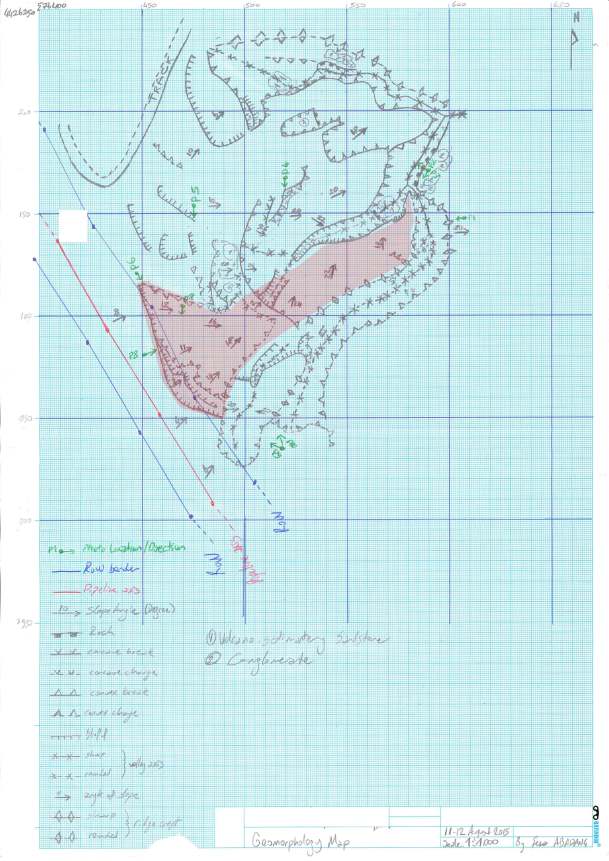 |
| Geomorphology Map Drawn by Me to Understand the Small Scale Debris Slide |
Comments
Post a Comment