Landslide Part 2
Landslide Investigation
Moving
masses have different variables that affecting the displacement. This
variables are controlled by geology of the site, climatic conditions,
human impact, natural impact, erosion and groundwater regime. Collecting
and determining the parameters of these variables is highly important
for analyzing of the moving body correctly. Even obtaining parameters
correctly, additional measures required for uncertainties (measured by
FoS) to achieve permanent stabilization.
The
first consideration should be understood the cause of the landslide,
then obtain sufficient data to model it and accordingly determine the
remediation options that best suit the obtained situation.
Correct
and efficient rehabilitation method can be obtained only by determining
cause of displacement, type and geotechnical parameters of the moving
mass, boundaries of the moving mass, shear strength parameters of the
failure surface and groundwater regime of the area. Therefore landslide
investigations require planned and detailed studies to determine root
& cause of the mass movement.
I have sorted investigations for landslide step by step in 8 main topics;
- Regional Geology
- Site Geology & Geomorphology
- Site Investigation Technic & Location
- Site Investigation Data & Laboratory Test Schedules
- Instrumentation Data
- Laboratory Test Results
- Modelling Landslide & Determining Geotechnical Parameters
- Determining rehabilitation Methods
1. Regional Geology
Assessment
of the regional geology begins with researching the available
information about wider area of concentrated location. Typical and
important sources of information are ; topographical maps, aerial &
satellite photography, geological & geomorphological maps-reports
and papers and field trip notes etc.
Based
on the known geology and geomorphology selected locations in the area
is investigated detailed to further the understanding of the overall
setting of the site. Particularly focus on factors such as stratigraphy,
low strength soil and rock units, groundwater system, weathering
patterns, tectonic deformation, other landslides etc.
In
these factors specially other landslides give you basis information.
Comparing the study area with previously failed masses will be guided
you about failure boundaries of the landslide and type of failure.
All collected information about regional geology will be used in step 2 & 3.
2. Site Geology & Geomorphology
Assessment
of local geology is important to localize the site in a regional
geological setting thus, underlying geological conditions and expected
ground model can be estimated. This estimations are useful in
determining ground investigation points.
Determining
geomorphology is important in mapping the boundaries and surface
features of a landslide to understand the landslide mechanism. This is
the most important step before decide on ground investigation methods
and locations. In this step preparing a geomorphological mapping will be
provided a vision to see big picture and to determine accurate position
of ground investigation points.
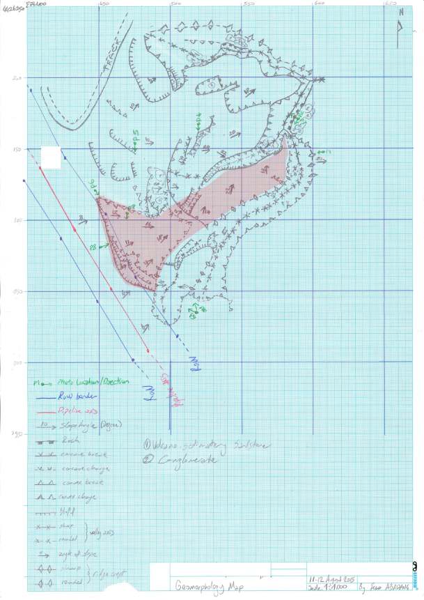 |
| Geomorphology Map Drawn by Me to Understand the Small Scale Debris Slide |
Visit Landslide page to read unified article series.
Hey very nice site!! Man .. Excellent .. Wonderful .. I'll bookmark your website and take the feeds
ReplyDeleteadditionally? I am satisfied to find numerous useful information right here in the put up, we'd
like work out extra strategies on this regard, thank you for sharing.
. . . . .
Thanks, I am going to post as much as possible when I find some time out of work.
Delete